Total for this ride: 52.7 miles
Total for this year: 1560.7 miles
Nothing better than getting paid to ride my bike...
Used the whole day to work on getting ready for the upcoming DiscoveRIT Western NY Bike Adventure, a 3-day ride from RIT to Niagara Falls and back that I'm leading at the end of the month. The goal today was to do a reconnaissance of the route we'll follow on the second day of the ride, a round-trip from Lockport to Niagara Falls. Although I've ridden from home to Niagara Falls a couple of times already, this is the first time I've done it leading a group of kids, with unknown abilities, and unknown equipment. So I picked a route that I thought would minimize effort and maximize safety. But I hadn't actually ridden on that route before, so I needed to scout it out to make sure I know where I'm going on game day, and there are no surprises. Turned out it was a good thing I did.
I was accompanied on this ride by my buddy Bob Callens, who graciously agreed to drive from RIT to Lockport, since the rack he has in his truck can handle two bikes (mine only takes 1...). When we got to town, we pulled into the Holiday Inn where we'll be spending the two nights of the ride. We popped into the hotel only long enough to drop off some power bars and Gatorade that we'll make available to the riders on days 2 and 3. Then we hit the road - about a mile down Transit St.., then west on Rt. 31, which is also NY State Bike Route 5, toward Niagara Falls.
That stretch of Rt. 31 really is pretty good for biking. There's some traffic, including trucks, but the shoulders are wide and relatively clean, and there are no significant hills. Still, it's a pretty long stretch - maybe 15 miles or more - and I'm not sure how my group of inexperienced riders will do after having ridden 60 miles on the Erie Canal the day before. It will be interesting to see how they hold up.
We had one encounter with a local farmer along the way. He was driving an old tractor on the shoulder, going in the same direction we were. We were able to catch and pass him without much effort. He pulled along side us when we had to stop at a light, and started chatting. He wanted to know where we were going, so we told him. Then he mentioned that he was headed, I think to some sort of farm show or parade or something, where his tractor would be on display. He told us it was a '58 John Deere. I almost said to him that my '57 legs were faster than his '58 John Deere, but I didn't.
When we got to the west end of Rt. 31, we needed to find the bike path which, according to Google Maps, would take us right down into the town of Niagara Falls. After winding through a quaint residential area, we found it, right near the Devil's Hole State Park. After crossing the bike/pedestrian bridge over the Robert Moses State Parkway, we headed south along the Niagara River toward the falls. The path we rode on was outstanding... it appears it was formerly the two south-bound lanes of the Parkway, which had been closed to vehicular traffic and marked for bike and pedestrian use. Although we did see a few others out using the path, I would have expected many more, given the location and the great weather.

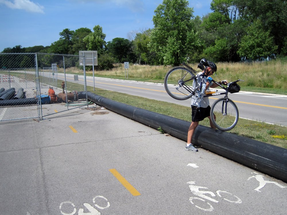
We followed the path maybe two miles and then ran into our first problem - the path was completely closed for construction. A few barricades and a chain link fence blocked our path. Fortunately, the work zone was only about 10 yards long, and we were able to walk the bikes along the grassy area that separated the bike path from the Parkway until we got around it. Once past the construction zone, all we needed to do was "portage" our bikes over a 24 inch pipe, and we were back in business. At least for a while. Another mile or so down the path and we hit another construction zone - which didn't afford any opportunities to bypass the area. Our only option was to backtrack and try another path which branched off of the one we had been using. This one quickly put us down on the surface streets in a neighborhood north of the falls, but we figured we had no other choice. So it was surface streets into the tourist district.

We made our way to Niagara Falls State Park without any further trouble. First order of business when we got there was to check out the "Top of the Falls" restaurant, where I hoped to bring the group for lunch when we arrived in a couple of weeks. It's a really cool restaurant with an incredible view of the Horseshoe Falls. There we were served by Magdalena, a nice young lady from Macedonia, who had just come to the US for the summer, and would soon be returning to her homeland for her final year of college where she is majoring in economics. We also met the manager of the facility, who booked us for a group event on August 30th, the day our 18 riders will show up, and who will work with me to set up a menu. This will be perfect - we'll show up, walk in, our food will be waiting for us, we'll eat, and then we'll cut the kids loose to explore the park until we get back together for the "Maid of the Mist" ride. Perfect.

Once we had taken care of business at the restaurant, Bob and I packed up the bikes and got ready to head back. As we were getting our act together, we chatted with a few folks who were clearly part of a large group of riders who were on some kind of tour. We found out that it was a group of about 120 people (wearing tie-dye shirts) from Oneonta, who were affiliated with a "Youth For Christ" chapter. This was the 30th annual ride like this one. Real nice people.

After mounting up Bob and I intended to retrace our steps back out of town and toward Lockport. However, as we left the park and headed north through traffic, Bob noticed some trails off to our left, toward the river. We decided to explore a little and see where they went. We discovered to our surprise that they led right back into the park - in fact when we were checking out the schedule for the Maid of the Mist, we could have hopped on right there and saved ourselves all of the winding through pedestrians and cars. This was a major discovery, because we were now confident that we would be able to get both in and out of the park without having to deal with traffic. Turns out it wasn't quite as easy as we had hoped... there were still a few minor detours along the way, but all in all, we think we're in pretty good shape for the group ride in a couple of weeks.
On the way back up to Rt. 31 we ran across a couple of stragglers from the YFC group (apparently one of them had gotten a flat). We rode with them back to the bridge over the Parkway where their group was waiting, and then we hopped back on Rt. 31 for the long ride back to Lockport.

 Anyway, today's ride was my first with Joe since we rode (OK, coasted) down Haleakala on Maui almost exactly one year ago. We didn't go quite as far today, but we definitely put in more effort. After rolling out of our neighborhood and through the Village of Victor, we headed up the dreaded Boughton Hill, former home of the largest village in the Seneca Indian Nation, and probably the highest spot in town. After getting to the top, we kept going south until we made a left toward Boughton Park - a quaint little local park, formed as were other parks in the area, by glaciation during the last ice age. We took a quick break, rehydrated, then continued our loop, riding past several horse farms before rolling back through the Village and then home. An excellent ride on a beautiful day.